In a generally quiet month, October still managed a little bit of everything and had some rather curious contrasts: the earliest autumn day in my records that failed to attain 10°c, followed three days later by the latest autumn day in my records to attain 20°! We had some fabulous sunny days, a lengthy dry spell either side of mid-month, but becoming wet thereafter and unsettled at the end of the month.
Apart from the 5-7th the month was dry and settled for the 1st-20th with high pressure dominant. The month then became unsettled from the 21st with rain becoming increasingly frequent and heavier. During the beginning of the spells of high pressure, 1st-4th and 8th-20th we enjoyed some decent sunny days, but becoming increasingly cloudy towards the end of those periods. There were some cold nights, although we only had the one air frost, with the mean minimum for the month down on average, but this was more than offset by the mean maximum, resulting in the mean temperature for the month being slightly above average.
MSLP of 1018.4 Mb was +7.5 Mb above the average for October with high pressure in charge during the 1st-4th and in particular 8-20th when we had the dry and settled period. Low pressure was infrequent and confined to three short separate spells, 5-7th and the other two of which were after the 20th.
Overall a mean minimum of 4.86°c and a mean maximum of 13.70°c saw the temperature 0.2°c above the 1981-2010 average, but making it the coldest October since 2012. The highest maximum temperature recorded was 20.4°c (6th), the lowest minimum -1.0°c (14th).
Rainfall of 74.1 mm (Crosby Ravensworth School 76.7 mm) made it the driest October since 2010 (the 3rd driest of the 9 recorded by myself) and here at Maulds Meaburn was 56.6 % of average for 2007-14. Locally rainfall was typically about half of average, but with the least deficit in the east of the county, Seathwaite had just 40.5 % of average, whilst Kirkby Thore had 79.3 %.
At the Met' Office site at Newton Rigg, 46.2 mm (43.2%) made it the driest October since 2003 and in a series back to 1914 this makes it the 15th driest in that time (1 year of missing data). A mean temperature of 9.2°c is the coldest since 2012 and in the same series back to 1914 there has been 39 warmer, 55 colder with 3 years having the same mean temperature (4 yrs of missing data).
Figures from the Environment Agency’s rainfall sites were, (figure in brackets being the monthly average for 1961-90) ‘Data kindly provided by the Hydrometry and Telemetry team of the Environment Agency (Penrith)’:
Kirkby Thore 52.2 mm (65.8 mm)
Brothers Water 130.5 mm (276 mm)
Nunwick Hall 52.6 mm (85.1 mm) and
157.6 mm at Seathwaite Farm (Borrowdale - 389 mm [average for 1981-2010]).
1st - 4th
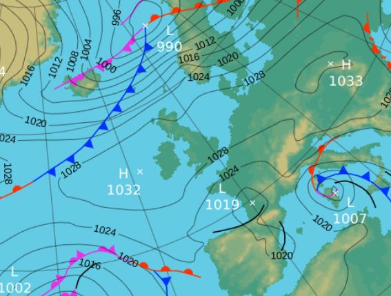
The elongated area of High pressure (HP) lying east-west over the UK that had brought the good weather at the end of September continued through to the 4th, but with mixed fortunes. The 1st was simply an excellent day, (I would venture the best day of the year?), wall to wall sun on a perfectly clear and calm day that peaked at 19.3°c (66.7°f) - see the synoptic chart below.
The 2nd was still sunny but a little hazy with fog descending in the evening and which like the 1st had started by just missing out on recording an air frost, although both, along with the 3rd, had seen ground frosts.
The 3rd was then in contrast to the previous two days as it remained foggy throughout the day with the temperature only ranging 7-9°c, although recording a maximum of 9.6°c (this maximum actually being recorded on the 4th, but 'thrown back' to the 3rd).
The 4th saw early mist clear to leave a cloudy day and now the HP was retreating east, finally allowing numerous low pressure (LP) systems in the Atlantic to make east.
5th - 7th LP to our south pushed a frontal system north during the morning of the 5th which gave a spell of heavy rain (11.5 mm) before easing back with light rain persisting into the afternoon.
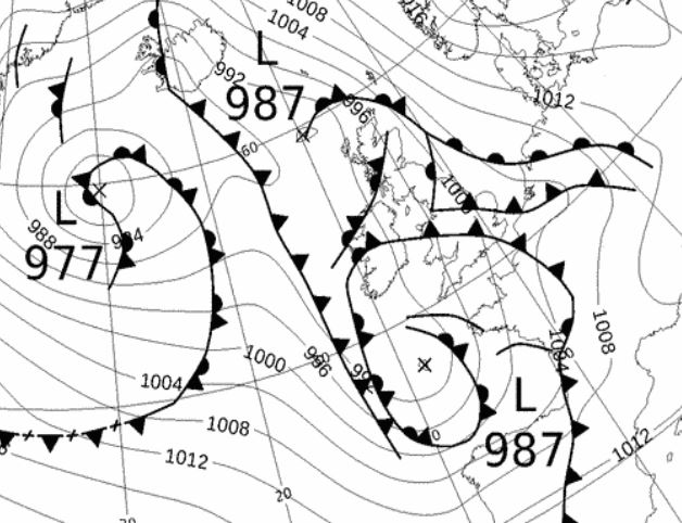
A warm south-easterly flow had been introduced by this LP and now the 6th (see synoptic chart below) saw fronts from overnight clear north and with LP centred near Cornwall and moving east, the airflow veered, becoming southerly and even warmer. With the afternoon brightening to sunny intervals, that coupled with the southerly flow saw the temperature peak at 20.4°c (68.7°f), easily the month's warmest day and the latest such autumn day to hit the 20°c mark and yet pressure was at a month's low of 995.6 Mb!
8th - 20th HP then returned, becoming firmly established and dominant and giving an extended period of dry and settled weather. Sunny days at first, becoming increasingly cloudy with some quite chilly nights. Temperatures fell slightly below average from the 12th as the winds changed to north-westerly then north-easterly.
The HP originated in Normandie, pushed north, settling over Sweden then the USSR, but maintaining a strong ridge over the UK. From the 16th a separate area of HP (1030 Mb) developed just of the west coast off Scotland.
We had decent amounts of sunshine and above average temperatures, 15-16°c, for the 8-10th and after a cloudy day 11th, the sun returned 12-15th albeit with the drop in temperature.
The season's first air frost, -1.0°c (30.2°f) (Shap -2.9°c), finally came on the 14th with clear and calm skies overnight, whilst the ground frost on the 15th was the 100th of the year. Cloud then became stuck within the HP system during the 16-20th and they days were all a little grey, the 19th seeing a weak occlusion give some rain in the evening. LP then arrived later in the day on the 20th as the HP, now to our south-west, let go of its grip with moderately heavy rain arriving at 2200 Hrs.
21st - 24th The frontal system connected to LP systems over Iceland and in the mid Atlantic that had arrived late on the 20th, giving a spell of rain overnight into the 21st, cleared to give some brightness during the 21st. This saw the temperature rise to 18.2°c (Shap 16.8°c) to make Maulds Meaburn the warmest location in NW of England that day.
Behind the cold fronts of the 21st, the 22nd was a good drying day in a somewhat brisk and noticeable westerly flow, albeit with sunny intervals. Cold fronts overnight into the 24th brought some rain upto 1015 Hrs followed by a sharp drop in temperature as the cold front passed through.
25th - 27th HP to our south-west, tracking north-east over France then Germany, extended north over the UK and whilst the main feature for the 25th the 26-27th would see us lie in between that HP and LP out in the Atlantic that was trying to push fronts our way. With a south-easterly flow and cloudy skies it remained mild by both day and night, but with little brightness.
28th - 31st The fronts out in the Atlantic finally took charge on the 28th through to the end of the month which saw a marked downturn in the weather; rain was prevalent and at times fell heavily. The 28th saw a slow moving occlusion then cold front pushed over the UK which resulted in a wet and miserable day with the 22.0 mm easily making it the month's wettest day. Indeed a new frontal system (but still associated to the same LP) overnight into the 29th topped up that final amount - see synoptic chart below.
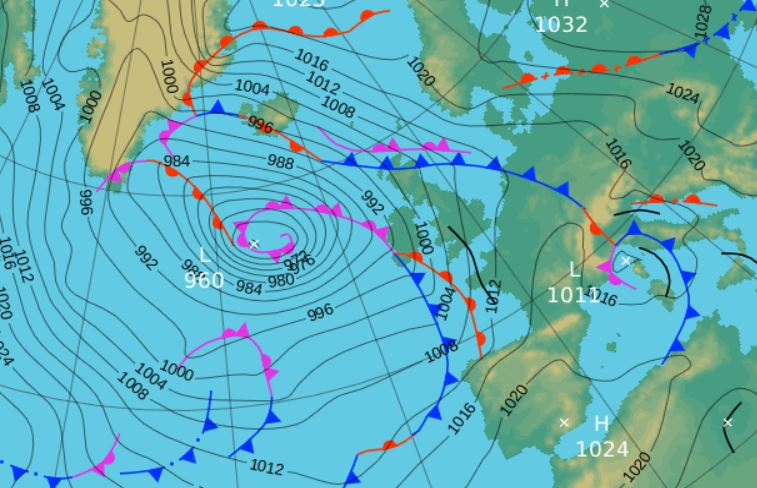
The LP system to which these fronts were associated wouldn't make any headway east, instead deepening to 956 Mb and slowly trundling north towards Iceland and becoming virtually static, but with fronts always trailing off.
An assortment of LP systems were lining up in the Atlantic come the 30th with frontal systems bringing more rain overnight and through the morning and again overnight into the 31st.
Rainfall totalled 74.1 mm for the month, with rain recorded on 15 days of which 11 were 'Wet days' (1.0mm +).
The Mean Temperature for the month was 9.28°c -- The Mean Max' was 13.70°c -- The Mean Min' 4.86°c.
We had 1 Air Frost in the month (year 43) -- Grass frosts totalled 8 (year 102).
The 1 foot soil temp ranged from a low of 9.8°c on the 18th and 26-27th to a high of 12.8°c on the 7th -- with a monthly mean of 10.8°c
The 1 meter soil temp ranged from a low of 10.5°c on the 29th to a high of 12.3°c on the 1st -- with a monthly mean of 11.4°c
COMPARISONS:-
* October 2015 rainfall was 56.6% of the October average for 2007 - 2014
* October 2015 was 0.46°c colder than the October average for 2009 - 2014 and 0.2°c warmer than the local long term average 1981-2010
* 2014 Jan - Oct TEMP 10.38°c -- RAIN 1159.4 mm
* 2013 Jan - Oct TEMP' 9.17°c -- RAIN 896.8 mm
* 2012 Jan - Oct TEMP' 9.08°c -- RAIN 989.2 mm
* 2011 Jan - Oct TEMP' 9.75°c -- RAIN 1016.4 mm
* 2010 Jan - Oct TEMP' 8.73°c -- RAIN 550.5 mm
* 2009 Jan - Oct TEMP' 9.76°c -- RAIN 854.3 mm
* 2008 Jan - Oct TEMP' -- RAIN 1205.0 mm
This makes the Jan' to Oct' period of 2015 0.52°c colder than the average for 2009-14 and with 90.3% of average rainfall for 2008-14
JANUARY 2010
FEBRUARY 2010
MARCH 2010
APRIL 2010
MAY 2010
JUNE 2010
JULY 2010
AUGUST 2010
SEPTEMBER 2010
OCTOBER 2010
NOVEMBER 2010
DECEMBER 2010
JANUARY 2011
FEBRUARY 2011
MARCH 2011
APRIL 2011
MAY 2011
JUNE 2011
JULY 2011
AUGUST 2011
SEPTEMBER 2011
OCTOBER 2011
NOVEMBER 2011
DECEMBER 2011
JANUARY 2012
FEBRUARY 2012
MARCH 2012
APRIL 2012
MAY 2012
JUNE 2012
JULY 2012
AUGUST 2012
SEPTEMBER 2012
OCTOBER 2012
NOVEMBER 2012
DECEMBER 2012
SUMMER 2012
REVIEW OF 2012
JANUARY 2013
FEBRUARY 2013
MARCH 2013
APRIL 2013
MAY 2013
JUNE 2013
JULY 2013
AUGUST 2013
SEPTEMBER 2013
OCTOBER 2013
NOVEMBER 2013
DECEMBER 2013
REVIEW OF 2013
JANUARY 2014
FEBRUARY 2014
MARCH 2014
APRIL 2014
MAY 2014
JUNE 2014
JULY 2014
AUGUST 2014
SEPTEMBER 2014
OCTOBER 2014
NOVEMBER 2014
DECEMBER 2014
WINTER 2014
REVIEW OF 2014
JANUARY 2015
FEBRUARY 2015
MARCH 2015
APRIL 2015
MAY 2015
JUNE 2015
JULY 2015
AUGUST 2015
SEPTEMBER 2015
© Darren Rogers 2015
Want to comment on this site? email